While survival books describe and survival kits usually contain the obligatory compass, few modern outdoor adventurers actually do know how to use one. After examining the utility and limitations of compasses, this post continues to advocate that accurate navigation is dependent upon accurate timekeeping. Two and a half centuries ago seafarers relied upon their best guess called “dead reckoning”. The appearance of the sextant and chronometer combined with celestial observation finally allowed for the fairly accurate fixation of a position. Modern commercial airliners have compasses, radar and other radio backup navigation devices. While today pilots and some Naval officers are trained to navigate by alternate means, it is upon GPS that they predominately rely. To provide a good 3- dimensional fix or position to a GPS receiver, at least four geosynchronous satellites in orbit have to know their own latitude, longitude, altitude and critically – the accurate time (which is carried on-board).

Even in the hands of an amateur a compass can be useful. For example once a simple bearing of a distant object is taken then a person can walk through darkness or dense vegetation to get there by following the bearing. He can also return to his starting position by reversing his bearing (either adding or subtracting 180°). If a couple of unique landmarks are visible in the distance then re-locating a position can be simplified by using a compass. If for example a prospector wanted to bury a treasure in the desert but be able to return to retrieve it; he could take two readings of widely separated landmarks at that location. Months later, he could return to the general area and walk until he acquired his first bearing to the associated landmark, and then walk along that vector until he acquired his second bearing to its associated landmark.
Assuming that one is in the wild and wants to leave a point of origin on a long walk but return, then a compass, pencil and sheet of lined notebook paper can be very handy. Because of hills, gullies or other obstructions the direction of travel might change several times. Using the lines of the notebook paper as visible representation of magnetic north / south lines, recordings of changes in compass bearings and distances in-between (measured perhaps with something like paces – every drop of the left foot) can be projected upon the paper so that a different route, a direct short cut back to the point of origin can be navigated if so desired.

Compasses are consistent within small localized areas but when longer distances of travel are involved they become unreliable for navigation unless adjusted. The problem is that compasses don’t point to true north. Compasses don’t even point to magnetic north come to think of it. Compasses actually align themselves with the sum of many – sometimes conflicting lines of magnetic force. Compass readings can be affected by metal objects worn or carried by a human, by the metal in a ship or aircraft and depending upon location – by unseen anomalies beneath the surface of the earth. What we call the magnetic north pole doesn’t actually stay in one place and lately its rate of movement has been accelerating.
It is assumed (since no one has actually seen it) that the earth’s viscous molten rock mantle and liquid outer core are heated by a continuous and ongoing radioactive decay. Complex convection currents in the magma cause not just one but several magnetic dipoles to occur – and these have different orientations and different intensities.

Another factor called inclination or magnetic dip also pulls upon a compass needle. Near the equator, magnetic lines of force are roughly parallel to the surface of the Earth. Near the Poles however, the compass needle dips dramatically perpendicular to the Earth’s surface because of influence from the planet’s lines of magnetic force. There is a somewhat confusing distinction between the averaged geomagnetic pole and the regular magnetic dip pole where in the northern hemisphere a compass needle should point directly downward. * Kyoto University charts of geomagnetic and magnetic dip pole locations.
The magnetic dip pole has wandered more than 1,000 kilometers from where its location was 180 years ago. Presently its position is something like 1,170 kilometers (727 miles) from where the true or geographic North Pole really is. Back in 1831 the magnetic dip pole was moving about 6 km per year but that rate has accelerated to a disturbing 24km per year. Every 200,000 years or so the earth’s magnetic poles do a ‘flip’, and such a geomagnetic reversal is long overdue.
* A web site suggesting that the current rate of pole shift is alarming.
Most maps or nautical charts are drawn with a true geographic north / south orientation as determined by the axis of the earth’s rotation. Such maps will often feature a “compass rose” somewhere to indicate compass magnetic variation or declination. Since there are so many fluctuating and unpredictable forces influencing compass readings these maps or charts need to be updated on a regular basis to be useful. Maps or charts older than a year or two might possess incorrect magnetic variance which could lead to gross navigational error. If for a small example a hiker was unknowingly following a compass error of 14°, he would stray off course ¼ mile for every forward mile of travel.


Higher resolutions of these two magnetic declination images are publicly provided by NOAA (National Geophysical Data Center) and are available <here>. [ One should note that between these two images that the (+/-) colors of the isogonic lines are reversed ]. From the second image it can be appreciated that for an airplane traveling up or down the N. American Atlantic coast perhaps, continual compass corrections must be made to maintain precision. In the past when compasses were the dominant navigational aid for pilots or ship captains, astute attention was paid to such variation. Today a pilot of a small plane would probably plot a course on a map and then convert those true north bearings to magnetic north bearings that his instruments would actually use in the cockpit. Many of today’s affordable GPS receivers which read true north are actually capable of quickly calculating magnetic north for a pilot.
Useful magnetic field calculators which will estimate the magnetic declination for any location, can be found on the Internet
http://geomag.nrcan.gc.ca/calc/mdcal-eng.php <Canadian>
http://www.ngdc.noaa.gov/geomag-web/
Compasses have their shortcomings as they are affected by unseen forces within the earth, by the metal of a ship or aircraft, watch on your wrist, metal trinkets in your pants’ pocket or even by solar flares. Only when these complications are understood and compensated for do compasses deserve respect as dependable navigational aids.
Mariners of old had to be on constant vigil night and day, prepared for any eventuality from oncoming bad weather to avoiding obstructions like uncharted islands. In those days any charts (sea maps) they may have possessed were inaccurate. The technology necessary to accurately fix a position upon a chart was missing. Exploration and commerce by sea was exploding by the beginning of the 18th century. Nautical disasters due to navigational errors were very common. For instance in 1707 one of the worst maritime disasters in British history occurred in the darkness as part of the Mediterranean Fleet wrecked on the Scilly Isles (SW English channel / not Mediterranean Ocean). Four ships, more than 1,400 sailors and the miscalculating British Mediterranean commander – Admiral Shovell were lost. <link>. Otherwise, ships and seamen weren’t getting lost in the typical sense, but they lacked the ability to return to a previously discovered island which might be out in the middle of an ocean for example. By 1714 the problem of accurate navigation was so intense that the British Parliament passed the “Longitude Act”, awarding a (£20,000 / $4.8 million today) cash prize for a suitable solution for determining longitude at sea.
———————————————————————-
The open ocean can quickly become one of the most inhospitable, life threatening environments imaginable and this was especially true in previous centuries when sailing ships were little more than slap shod wooden corks bobbing about in a liquid immensity. The life expectancy of the average sailor was low but the pay was high. Falling out of the shrouding or being washed overboard in a storm were constant hazards. On the long exploratory type voyages beginning around the 15th century, sailors also contended with cramped living space, squalor, bad food and water, hunger, communicable and other diseases like scurvy caused by malnutrition and lack of vitamin C. Although the modern reader may hopefully never be subjected to similar or such persistent rigors of day to day survival he or she might try to appreciate how crucial navigation at sea was then to one’s own life or death. These explorers, facing the unknown on the far side of the world were adventurers and heroes in the strictest sense and their accomplishments in the face of hardship have seldom been equally matched in modern times.
Before the first publication of lunar and astronomical data in 1767 the main (European / Western) typical navigational aids in use in addition to the compass were things like astrolabes, cross staffs, backstaffs, quadrants, traverse boards and chip logs. To measure the speed in knots – a ‘chip’ might have been simply a large clump of tethered wood thrown over the side of a ship. As the ship moved forward the line played out in a seaman’s hands per time interval and the equidistant ‘knots’ in the cordage were counted. ‘Dead reckoning’ is the process of determining one’s present position or plotting one’s future course by projecting course and speed from a known past position. The effects of wind drift (leeway), current drift and steering error are usually not considered. For centuries whaling and fishing ships which did not require critical navigational accuracy, managed to exploit and return from the sea with just these early navigation aids combined with dead reckoning.

https://en.wikipedia.org/wiki/File:Lunars-star-map.jpg
Thanks to: Michael Daly (2007)
Lunar distance navigation is an early type of celestial navigation but the two phrases have come to signify separate processes. When using the Sun by day or Polaris by night, determining latitude was a fairly straight forward process whereas accurately determining longitude was not. Moving approximately the distance of its own diameter every hour against the background sky, the moon’s position in relationship to another prominent celestial body can be used to render a fair approximation of GMT and therefore the longitude. The angle between the moon and another body like Jupiter is corrected for parallax and searched for in a table of lunar distances to determine the time such a distance should occur. The process is tedious and complicated. The first authoritative Nautical Almanac full of moon transit data and other celestial sight reduction datum was published 246 years ago by the Royal Greenwich Observatory and is still in publication. The main utility of complicated lunar distance navigation lay in its ability to predict GMT in the absence of an adequate timepiece.

– the latitude can be estimated with a simple protractor
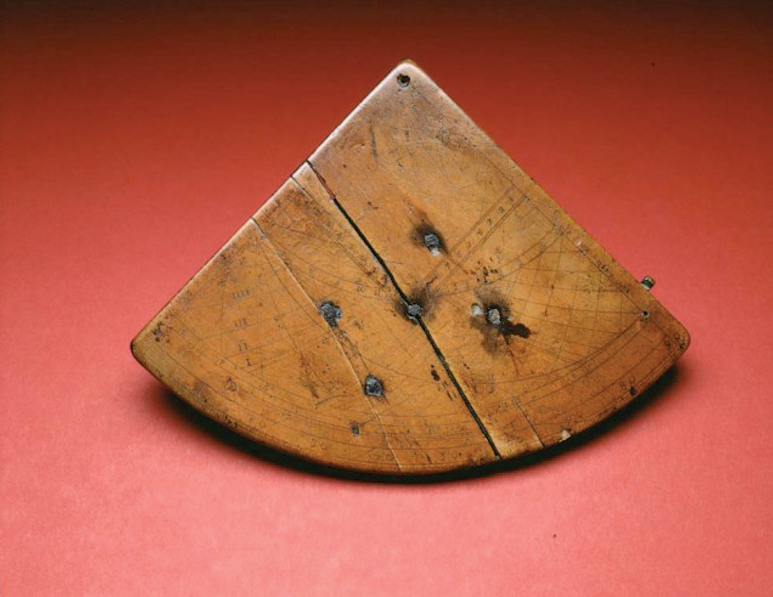
The octant was a navigational aid that made its first physical appearance by about 1742 and soon replaced or supplanted older instruments like the astrolabes and cross staffs. Mathematician and physicist Sir Isaac Newton dreamed up the reflecting quadrant concept some four decades before one was actually constructed. Stemming from the Latin word “octans” the octant’s frame spans one-eighth or 45° of a circle and can measure arc angle as large as 90°. Octants were very useful for most meridional altitude measurements of the sun or for some celestial readings, but the arc of measurement was limited or inadequate to capture both the horizon and bodies positioned more directly overhead.

The sextant gets its name from the Latin word for one sixth – “sextāns” and has an arc spanning 60°. Also using two mirrors the sextant can measure angular distances between two objects that are as much as 120° apart. Taking a reading with a sextant is simple but knowing what to do with that number – not so much.

To use the sextant the telescope must be focused on the horizon. The celestial body to be shot is found and the sextant aimed at it. The body is brought down to the horizon by moving the arm along the arc and then the arm is clamped. The micrometer knob makes small adjustments while the instrument is swayed slightly from side to side, until the heavenly body just brushes the horizon. When this is achieved a note is instantly made of the time, seconds first, then minutes and hours, then the name of the body and its observed altitude. Every second of time counts – an error of 4 seconds equates to an error of a nautical mile in the position. In modern practice for people still skilled in this science, a sextant plus a piloting calculator or old fashioned navigational almanac with trigonometric sight-reduction tables still permit navigation by Sun, Moon, visible planets, or any one of 57 navigational stars whenever the horizon is visible. To accurately fix his position a pilot (navigator) actually had to preform sight reduction on three separate celestial bodies; using their “earthly positions” (at a given GMT time) – to calculate his.
The sextant largely displaced the octant because it was a more capable instrument. The two were used side by side for many years, with the less expensive octant being delegated the more routine task wherever applicable. The Lewis & Clark expedition to explore the American West, toted both an octant and a sextant with them on their overland two and a half year / 7,689 mile trip. When encountering mountains obstructing his view of the horizon, Lewis employed an artificial horizon made from a dish of water. This informative <link> illustrates how Lewis accurately determined his latitude using a “noon shot”. It explains how he corrected for index error, refraction, parallax, the sun’s semi-diameter and the sun’s declination.

– gimbaled chronometer (c. 1840)
Google free to use or share filter.
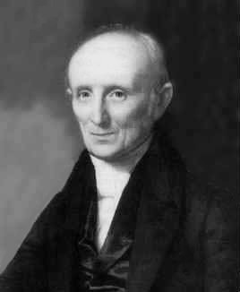
Getting back to the Longitude Act of 1714 and the British Naval and Merchant Marine’s desperate quest for an easier, more accurate method of establishing position we finally fit the last piece of the jigsaw puzzle with a crucial timepiece. The first chronometers were so important and so expensive that they are still recognized by individual names. After many years of effort and perseverance a clock maker named John Harrison (1693-1776) finally produced by 1755 a timepiece (H4) with exceptional accuracy that was capable of withstanding the rigors of life at sea (continual- occasionally rough motion, humidity, salty environment, temperature change). Finally accurate navigation and map-making became simplified and achievable because along with the sextant and nautical almanac, an accurate representation of GMT (Greenwich Mean Time) could now be carried around the world. Harrison’s recognition and reward were to be long frustrated by ‘The Board of Longitude’ but that is another story.
* A chronograph is a wristwatch with a stopwatch feature.
* The H4 made two trial trips Jamaica and Barbados.
* A simpler less accurate chronometer named K2 accompanied an expedition in search for the Northwest passage in 1771 and later the infamous Captain Bligh before the mutiny on the Bounty. K2 changed hands many times.
* K1 which was Kendall’s faithful copy of Harrison’s H4 participated in Cook’s 2nd & 3rd voyages. K3 was also carried on Cook’s 3rd voyage.
* Gene Roddenberry’s protagonist ‘James T. Kirk’ captain of the star-ship Enterprise in Star Trek books, TV series and movies was probably named after the real life explorer ‘Captain James Cook’ – who literally did go “where no man had gone before”. Skilled in mathematics, Cook’s chart making of Newfoundland and the St. Laurence during the ‘Seven Years Years War’ brought attention to his talent by the The Royal Society of London. Accompanied by other talented men Cook’s 1st voyage (in HM Bark Endeavour) lasted 3 years (1768-71). The expedition was the first to circumnavigate and map New Zealand and explore and map the also unknown east coast of Australia. Cook’s 2nd three year voyage (1772-75) in the ship HMS Resolution, among other feats circumnavigated the globe at a very inhospitable southern latitude (crossing the Antarctic Circle), found a solution for scurvy and claimed and mapped South Georgia and the South Sandwich Islands. On his final voyage (1776-79) Cook (accompanied by K1, K3, HMS Resolution and midshipman- turned lieutenant William Bligh) discovered Hawaii, explored the western American coastline from California to the Bearing Straight and in search for a Northwest Passage sailed for many weeks above the Arctic Circle. Returning to Hawaii instead of Tahiti for resupply of provisions, Captain Cook was killed and literally cooked by the Hawaiians who may not have eaten him but kept his bones. Of all the peoples they encountered (including a Russian in Alaska, Eskimos, Nootka s, Australian aborigines, Tongans, Samoans, Fijians, Māoris and Indonesians) it was the too often visited Tahitians that Cook and Bligh viewed with something akin to contempt.
This post merely glazes over the mechanics of practical navigation and goes into no detail. Oceanography and meteorology are important earth sciences that a well rounded marine navigator should have some knowledge of. Geodesy is a science concerned with the exact positioning of points on the surface of the earth. Variations in gravity affect measurements of the earth’s surface and therefore are pertinent to understanding precision navigation. Navigational mathematics requires a solid understanding of plane and solid geometry and plane and spherical trigonometry. For the reader wishing to learn more about traditional navigation there are many resources – but perhaps none more respected than two old publications mentioned next.
Patterned after an older book of the Royal Navy but much improved, Nathaniel Bowditch’s “American Practical Navigator” has been published for over two centuries now and has been revised and updated about 55 times. The current Bowditch retains its well written curriculum on traditional navigation technique and adds new information on radio detection finding, LORAN, radar navigation, satellite positioning and so fourth. The current Bowditch is published by the Defense Mapping Agency -Hydrographic Topographic Center but is also available as a free 35.9 Mb / 882 page /.pdf download.
Being printed now in its 67th edition, Chapman’s Piloting & Seamanship is only 100 years old. This 928 page book began as a request and commission for a training manual to be written– from the Assistant U.S. Secretary of the Navy, Franklin D. Roosevelt. Full of navigation educational information, this publication is more geared to the needs of small watercraft rather than for large oceangoing craft. The book is not free but with 3 million copies having been printed it can easily be found in libraries or in new or used versions on Amazon.com and perhaps eBay. <link>
[ Note to self – ]
11/9/2013

The GPS (Global Positioning System) works by land based receivers interpreting the read only microwave signals that are broadcast from satellites orbiting in space. GPS satellites continually broadcast time, orbit location, health status and a continual system almanac (locations of other satellites) back to earth. Not the first satellite positioning system, GPS is still the only current fully operational such system and is of critical strategic and economic importance. As this technology continues to supplant older navigational technology the reliance upon GPS becomes more inflated. GPS’s ever-growing hegemony faces attack on several different fronts.
Each of the 32 or so currently working GPS satellites in medium Earth orbit house a cesium based atomic clock. Although other atomic clocks can exploit hydrogen or rubidium it is the very precise frequency of resonance in cesium-133 that these space born timepieces employ. *Cesium (or caesium (Cs) – atomic #55) is a very reactive alkali metal that is liquid at room temperature. Aside from its mild radioactivity cesium reacts very violently with water and is employed in certain military flares that can only be seen using infrared or night vision equipment. Also, the SI (metric) second is currently defined by interactions or periods of radiation within the cesium-133 atom. That very constant frequency (9,192,631,770 Hz) corresponds to an oscillation frequency in the SHF-X microwave band. The GPS program began somewhere around 1973 and the first experimental satellite was launched in 1978. In 1978 Korean Air Lines Flight 902 wandered (due to bad navigation) over Soviet airspace and was shot down. Another (Korean) civilian airliner (KAL 007) was shot down by a Russian interceptor in 1983 and at the time something like 8 GPS satellites (sill in the feasibility stage of development) might have been in orbit. After 269 passengers in the Boeing 747 were killed in KAL 007 the U.S. president (Regan) ordained that some GPS technology should be made available to civilian navigation for the public good. Following another presidential order (Clinton) in 1996 the GPS “selective availability” feature was turned off and global users could receive a non-degraded signal. These navigational satellites have a short lifespan. As of 2013, sixty four GPS satellites have been launched – the older non functioning ones were retrieved while NASA still had Space Shuttles.
With the help of their atomic clocks every GPS satellite generates two UHF microwave carrier signals which beam information back to earth – (L1) @ 1.57542 GHz and (L2) @ 1.2276 GHz. Any GPS receiver on earth must determine its own position from the differing travel times of signals from several satellites. At least four GPS satellite signals are required to give a proper 3-dimensional fix (time, altitude, latitude and longitude). Most receivers however have software to extrapolate approximate location while receiving signals from only three satellites (using last known location in the calculation for example). Some civilian applications that do take advantage of the practically free and highly accurate GPS time signal are: the timing of traffic signals, cell phone base stations to synchronize signals, stock exchanges and financial intrusions to track money transfers.
In times of war the Department of Defense still has the ability to deny precision positioning information to enemies. It would not do to provide the very guidance necessary to allow ballistic missiles to come crashing down upon your head. “Selective availability” which was an intentional corruption to deny full system accuracy to unauthorized users has been turned off. The “P” (Precision) code can be encrypted however and then only DoD authorized receivers could use it. There are also export restrictions to GPS receivers that are capable of working at high altitudes and at high speeds (as might be used by ballistic missiles).
GPS signals are necessarily weak because there is not a whole lot of power available aboard a satellite to broadcast them. In localized areas the weak GPS signals could be vulnerable to intentional jamming, deliberate or non-intentional interference and to falsified signals carrying the GPS signature. On the home front GPS reception can be threatened by upstart communication companies. After acquiring radio spectrum close to GPS spectrum, one prospective broadband company proposed an action that would have drowned out GPS reception for everybody. * This article (Dec, 2012) indicates that GPS is vulnerable to deliberate manipulation and attack.
__________________
Added 10/30/2015
Dangerously content with and reliant upon GPS, the U.S. Navy abandoned the teaching of celestial navigation a decade ago. Potentially realistic threats to GPS have now reinvigorated instruction in celestial navigation!
LA Times article:
“In the era of GPS, Naval Academy revives celestial navigation“
_____________
Russia, China and the European Union either have or are constructing their own competitive (to GPS) satellite positioning systems. The Russian GLONASS (GLObal NAvigation Satellite System) has comparable capability with GPS and was completed with 24 satellites in orbit by 1995. As with GPS however GLONASS satellites require periodic replacement. As the fabrication and launching of these satellites is a costly drain on the Russian economy, the GLONASS navigational system has not been fully functional in recent times. In July 2013 a rocket carrying 3 new GLONASS satellites crashed. Some commercial receivers and cell phones are capable of using both GLONASS and GPS signals. The Russians are currently trying to establish a few GLONASS monitoring stations in the U.S.
* Called “Galileo” the EU’s version of GPS has been delayed because of the complication and sheer expense of launching and establishing the necessary satellite infrastructure. Presently (Nov. 2013), there are 4 Galileo satellites already in orbit and a total of 22 will be needed to meet full operational capacity. — * Update: * On August 22, 2014 Arianespace and the European Space Agency injected Galileo satellites 5 and 6 into bad orbits. Presently it is being determined if any useful service life can be retrieved after orbit corrections, or if it may be more expedient to simply destroy the satellites instead.
*The Chinese alternative to GPS is called “Compass” or “Beidou” (after the Big Dipper constellation). With 16 satellites already in service the Chinese positioning system hopes to be fully global, with 30 by 2020.
—————————–
Added 11/20/2013 — To encapsulate some additional navigational topics:
In the 1920s and 30’s civilian passenger service and mail service grew rapidly and congestion placed air traffic control problems in the lap of budding airports. During this period German engineers and aviators were at the forefront of developing radio navigation. Using direction finding loop antennas, a system was developed that allowed aircraft to approach airports at night or bad weather by “riding a radio beam”. The Elektrik –Lorenz beam became the first successful blind-landing aid / standard beam approach and was followed by others like the longer ranged Elektra-Sonnen, British Consol, and American VOR (VHF Omni Directional Radio Range) which is still in use around the world today. The LORAN (LOng RAnge Navigation) was a terrestrial radio navigation system used by both ships and aircraft, from WWII until three years ago (2010) when it was shut down for budgetary reasons . Although many small craft still relied upon LORAN, it was considered redundant in view of the new GNSS (Global Navigation Satellite System) systems.
The modern inertial navigation system (INS) aboard aircraft, spacecraft, ballistic missiles, ships and subs calculate a dead reckoning position continuously. A good INS computer gets input from multiple sources: gyroscopes, velocity meters, accelerometers and augmented (or corrected) satellite positioning information from land bases. With tens of thousands of people arriving and departing simultaneously from congested airports, the importance of navigational precision and situational awareness in aircraft control towers is paramount. Three augmented air navigation aids presently in existence are the FAA’s Wide Area Augmentation System (WAAS), the European Geostationary Navigation Overlay Service (EGNOS) and Japan’s Multi-functional Satellite Augmentation System (MSAS).
————————————————————–
The following figures all point to the very same prominent landmark.
33° 40’ 38.28”, -106° 28’ 31.44” (traditional)
33.6773 N , 106.4754 W ______(decimal)
33° 40.638 N , 106° 28.524 W __ (GPS)
There are at least three common ways to designate a position of latitude and longitude (the traditional degrees, minutes & seconds format, the decimal format and the not quite standardized GPS format). Conversion by hand, between these formats can be tedious and prone to errors. Here is a handy online converter.


.jpg/800px-thumbnail.jpg)
.jpg)
.jpg)