From the beginning mankind has had a subconscious appreciation of the cardinal directions. Whether early people consciously perceived the earth as being flat or spherical it was obvious that the sun predictably rose from one direction and set in another. An adventurer could travel parallel to the sun’s path or perpendicular to it and return without getting lost. Close observation of the sun’s position became necessary for both navigation and the quantification of time. Navigation and timekeeping happen to be closely intertwined today, with or without the sun. Over several millennium mankind’s timekeeping devices have advanced from sundials and clepsydra to chronometers and atomic clocks. Navigation aids have progressed as well; from compasses to sextants to GPS receivers. A well trained navigator is schooled in several alternative, perhaps archaic methods of orientation. In today’s modern day and complacent age; pilots, ship captains, sportsmen, search & rescue teams, stock exchanges, and even the military are precariously at risk for relying too heavily upon advanced technologies like GPS.

Way back in prehistory someone probably traced the shadows of a vertical stick or tree upon the ground. A line drawn between morning and afternoon plots of shadow tips will reveal an accurate East/West baseline. Upon this principle of shadows cast by the blockage of sunlight, sundials became civilization’s first time pieces. Some four thousand years ago Egyptians and Babylonians were erecting stone obelisk to serve as sundials. The Romans were to later adopt the practice. The first sundials however came from the ancient Sumerians who probably created the first true ‘civilization’, which in Mesopotamia predated the Babylonians by a good 2,000 years. The Sumerians brought us cruciform writing, irrigation and clock dials with twelve hours – because their number system was based on 12.
* “Clepsydras“ are water clocks. Several ancient civilizations (Egypt, Mesopotamia, India & China) had or developed clepsydrae {Gk} but Archimedes of Syracuse (287 BC. – 212 BC.) was famously associated with them. Archimedes who was a mathematician, physicist and astronomer determined that water would escape faster from a filled containment vessel than it would from a nearly empty vessel. Among other achievements Archimedes made improvements to Egyptian cleosydra designs that were already about 1,800 years old – in his day. Humorously, in about 430 BC. Athens, clepsydrae were being used to time court trials and prevent lawyers from talking too long. Mechanical clocks did not appear until about 1,300 AD.

Free to use or share filter: Google images
Judging by the shadow cast by the style (sharp edge) of the gnomon (entire body that cast a shadow) this sundial reads about 9:22 AM. This horizontal, garden variety type of sundial is popular because it is simple, easy to read and captures sunlight well. There are many other ways to construct a sundial however.
* When constructing or installing a sundial there are a few important procedures to follow. Long ago someone noticed that tilting the gnomon northward (in the northern hemisphere only) increased the sundial’s accuracy. The ideal installation is one where the gnomon points true (not magnetic) north and the angle of the style matches the site’s latitude as closely as possible. Corrections to a store bought sundial with an inappropriate style angle for a particular latitude can usually be compensated for by tilting the base and thereby the style also. Naturally, once positioned correctly the sundial should be fixed as permanently as possible to prevent any movement. Positioning a solar panel for optimum results requires some similar precautions.
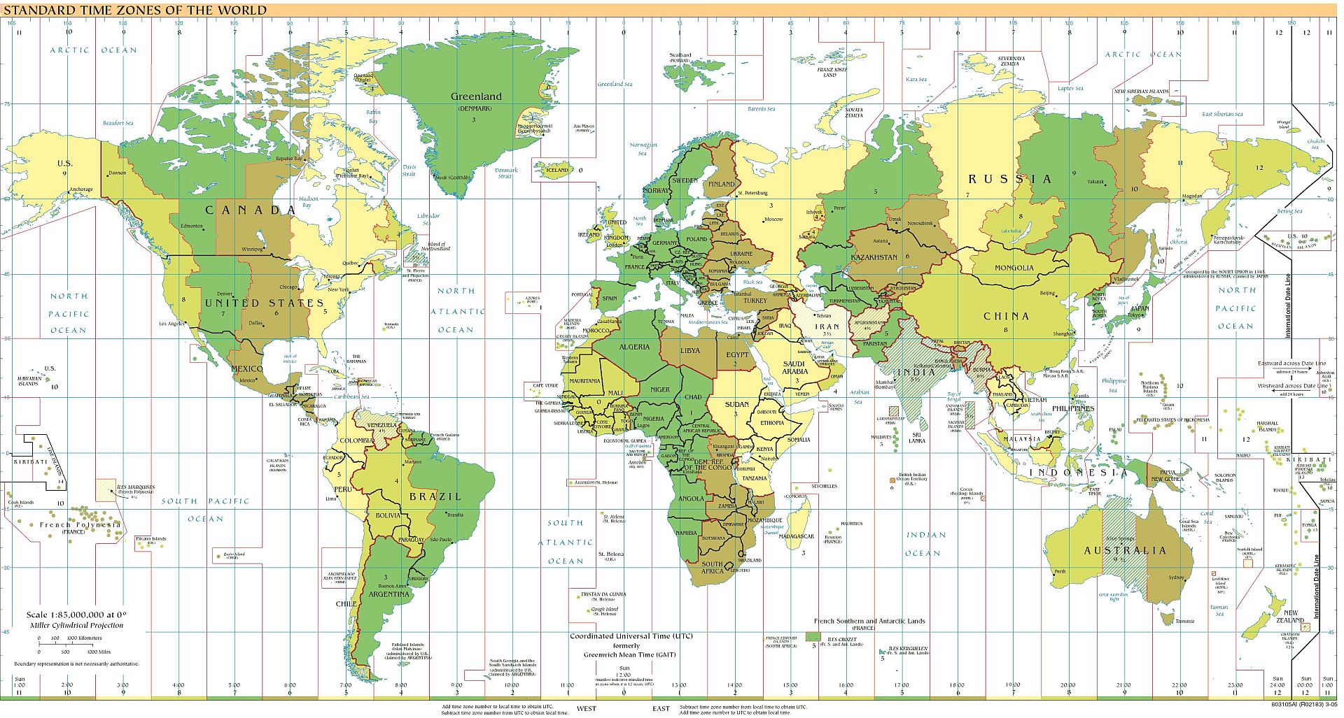
Prior to the mid 19th century, practically every municipality of any size had its own unique time. Noon was calculated according to the position of the sun at its zenith, at that location. The sun crosses over any meridian at midday (meridian comes from the Latin “meridies”, meaning midday). A meridian is an imaginary 12,428 mile long ‘great circle arc’ running from the earth’s North Pole to South Pole.
Time zones appear to have been conceived initially to simplify train schedules. Since the Earth rotates one turn in a day or 24 hours, many people (including Canadian rail pioneer Sir Sanford Fleming about 140 years ago) advocated the adoption of 24 standardized time zones [360° of longitude / 24 hours = 15° of longitude per hour]. Each 15° section of the earth’s circumference naturally differs from its neighbor by one hour. Such a simple plan to adopt 24 time zones was never embraced. Although all major countries eventually adopted the notion of ‘time zones’ by 1929, today the world has more than 40 ‘official time zones’. Further complicating the issue of time keeping is the controversial notion of daylight savings time (DST). Only of benefit perhaps to locations burning light bulbs far removed from the equator, DST was first adopted by Germany and then England in 1916 during WWI. America was to adopt DST in 1918. When Congress tried to repeal DST in 1919, President Wilson vetoed the bill twice because he liked to golf late in the evening. Since 1996 the European Union observes DST beginning with the last Sunday of March and ending with the last Sunday of October. Between 2007 and 2009 the U.S. and Canada observed DST 2/3 of the year (from the 2nd Sunday in March to the 1st Sunday in November). Determined to continue meddling with time keeping, Congress’s decision to advance DST’s 2010 established schedule by 10 days disrupted travel itineraries, business meetings, billing, record-keeping, machines with internal clocks and even caused one innocent person to be unjustly incarcerated for more than a week because of a school system’s lagging phone records.

Free to use or share filter: Google images
While people in the northern hemisphere are accustomed to seeing maps ‘right side up’, people south of the equator might view the situation differently. When you stand on a spherical planet the notion of up or down is arbitrary.
In the past, nighttime navigation in the northern hemisphere typically involved using Polaris – the North Star as a reference. In the southern hemisphere there is no convenient or prominent star near the apparent southern celestial axis. To determine ‘true south’ navigators first had to locate the constellation named “Crux” and next a pair of stars called the “True Pointers” to project the location of the southern polar axis.

Other stars nearby can be confused with Crux.

In 1869 New Zealand designed and then officially adopted a national flag with a stylized 4-star rendition of Crux in its field. Designed in 1901 but not made official until 1954, the similar Australian flag features 6-stars (one for each federated colony). The big star is called the ‘commonwealth star’.


Where the heck is North?
Back to finding north in the northern hemisphere, nighttime navigation was made a bit easier because Polaris hovers approximately over the north celestial pole, but this will change over time. In about 139 centuries the star named Vega will be the apparent North Star. A phenomenon known as axial precession causes the earth’s celestial axis to wobble about in a 26,000 year cycle.
Polaris is normally found by first identifying either Ursa Major (Latin for ‘Great bear’) or Ursa Minor (‘Little bear’). Also called the ‘Plough’ or ‘Big Dipper’ two stars of the seven from Ursa Major are used to point to Polaris. The North Star and the Big Dipper are the only features on the Alaskan state flag.

Polaris is the last star on the apparent ladle handle of the ‘little dipper’- (Ursa Minor). Cassiopeia is the third easily recognizable circumpolar constellation on the opposite side of Polaris from Ursa Major and is about the same distance away. The original definition or boundary of the “Artic Circle” was described by those stars within the “Circle of the Bears” and at that latitude they never drop unseen below the horizon. Both ‘bears’ and Cassiopeia therefore are circumpolar.

24 hr rotation of circumpolar stars
courtesy of: Mjchael
https://en.wikipedia.org/wiki/Circumpolar_star
The stars seem to rotate around the earth every 24 hours and move in the same East to West direction as the sun. A skilled eye can fairly accurately judge the time of night simply by observing the position of one of these constellations in the sky.
When the sun is not visible overhead ‘mother nature’ can provide a “landlubber” with clues pointing to north or south. Tree moss is a non-vascular plant that loves the shade which allows it to suck up the moisture and nutrients it needs to grow. Hiding from the sun that dries it out, moss flourishes on the north side of trees in the Northern hemisphere but on the south side of trees in the Southern hemisphere. The “Silphium laciniatum” or “compass plant” which is indigenous to central North America is another plant which provides a fairly reliable indication of north and south. Its basal leaves or fronds twist around perpendicular to the sun’s path to capture optimum sunlight.
————————————————————————————
Because of the images this post is growing long and so will be divided into two parts. The next several images are introduced with brief and minimal discussion to save space but most are pertinent to ‘time’ or help explain why the traditional methods of accurate navigation in the previous century were so tedious and complicated. Most of these images can be enlarged.

* With an eccentricity factor of 0.0167 the earth comes closest to the sun at the perihelion of the orbit, near Jan 4th (91.5 million miles) and is farthest away at the aphelion of orbit, near July 4th (94.5 million miles). That difference of 3,000,000 miles in distance has little effect on our climate but can introduce error to calculations. The amount of solar energy collected throughout the year remains approximately constant. The oceans and land masses collect solar energy and the earth’s atmosphere acts as a trap to hold it.


* The “ecliptic” is the plane of the earth’s annual orbit around the sun. The “celestial equator” however is an imaginary projection into space – of the earth’s equator.

* It is on the celestial equator that the constellations of the zodiac will be found. Depending upon the season of the year, certain zodiac (astrology) star constellations remain unseen because they reside in the daytime sky [the sun is between the earth and those stars].

* There are 360 whole integer lines of longitude and each is ½ of an imaginary “great circle” that bisects the center of the earth. Each arc or meridian (whole integer) is separated from its neighbor by 15 degrees (1 hour). A meridian is 1/2 the earth’s circumference or about 10,800 nautical miles (=12,428.4 Statute miles = 20,001.6 km) long. One minute of angle along a meridian defines a nautical mile (1,852 meters). Far apart at the equator, these meridians converge at the poles. Traditional lines of longitude and latitude are further subdivided by minutes and seconds (ex: DDD,MM,SS). By tradition the meridians are designated as either +/- 180 or as being <0 to 180> East or <0 to 180> West of the “prime meridian”. The prime meridian runs through the center of the Royal Observatory which is located in the south east Greenwich district of London, England. Greenwich Mean Time (GMT) normally differs from Coordinated Universal Time (UTC) or “Zulu time”, by less than a second.

* Except for the equator, lines of latitude are not great circles or arcs of great circles like meridians. Also caked “parallels”, these are numbered negatively or are designated as South of the equator when in the southern hemisphere. The summer (or June) solstice is marked by the Tropic of Cancer, and is the northernmost latitude where the sun can be directly overhead. “Tropic” stems from a Greek word meaning ‘turn’. So after the summer solstice the sun’s apparent path turns toward the equator and then the southern Tropic of Capricorn and winter (or December) solstice. The earth’s axial tilt is not actually fixed, but varies from about 21.1 to 24.5 degrees. – in a 41,000 year cycle. Both “tropics” are presently shrinking or moving towards the equator by 15 meters per year.

* Above is a mediocre illustration which attempts to demonstrate another movement of earth known as “axial precession” or “the precession of the equinoxes”. Like the wandering axis of a wobbling top (toy), the present celestial axis will move to point away from Polaris but return in a 26,000 year cycle.
Another factor that made a navigator’s computation complicated -was the “sidereal day”. A sidereal day is about 23 hours, 56 minutes, 4.0916 seconds long and is determined by the Earth’s rate of rotation measured relative to the fixed stars; not by a sundial shadow at high noon. A sidereal day for earth is about 4 minutes shorter than a solar day. After the earth completes a rotation on its axis (a sidereal day) it takes a little bit more angular rotation to bring the sun to its highest point at midday. This is because the earth moves almost 1º in its ecliptic orbit around the sun every 24 hours. This is why we add a “leap day” to the Gregorian calendar every 4 years.


Above are images of an 18th century Armillary sphere, a Celestial sphere and a circular sky map. To describe or locate stars and other celestial bodies in space, astronomers simply project the earth’s imaginary lines of longitude and latitude into outer space. This projection is done from the celestial equator; not the ecliptic. The term “declination” corresponds to latitude and “right ascension” corresponds to longitude. The celestial equator and ecliptic only intersect twice a year – during the equinoxes. The spring (vernal) and autumnal equinoxes are also the only two days where night and day are the same length. Instead of degrees; hours of right ascension are calibrated along the celestial equator, from the vernal equinox to the object. In the equatorial coordinate system hours of right ascension bear no relationship with time but are the 360 degrees of a great circle divided by 24 parts (360° / 24 = 15° of arc).
* There are probably more practical space exploratory type sites available now, because this site is several years old and is presently cluttered with advertisement. The more restricted (newer) version of Adobe Flash used prevents a skip to full screen which might allow you to ignore the adds. The music is still entertaining.
Yet to come in the second part of this navigational (Time & Direction) subject are the issues of compass error, magnetic dip, magnetic pole shift, dead reckoning, traverse boards, celestial & lunar distance navigation, octants, sextants, chronometers, atomic clocks, GPS and WAAS.
To be continued…

Some truly nice stuff on this internet site , I like it.
After exploring a handful of the blog articles on your web site,
I honestly like your way of writing a blog. I saved it to my
bookmark site list and will be checking back in the near future.
Please check out my website as well and let me know how you
feel.
Great article.
I leave a response whenever I like a article on a site or
I have something to contribute to the conversation. It is a
result of the sincerness displayed in the post I browsed.
And on this post Time & Direction (Part 1) | cactusbush.
I was actually excited enough to post a comment ;
-) I actually do have 2 questions for you if you do not mind.
Is it just me or does it give the impression like some of
the comments appear as if they are left by brain dead people?
😛 And, if you are writing at other online sites, I would like to keep up with you.
Would you list all of your community pages like your twitter
feed, Facebook page or linkedin profile?
Quote:
“Is it just me or does it give the impression like some of
the comments appear as if they are left by brain dead people”?
Quote:
“Would you list all of your community pages like your twitter feed, Facebook page or linkedin profile”?
No I don’t think so. Yes I have a couple of other websites and a couple of other identities. They are not linked to or revealed on this blog for a reason.
Keep on working, great job!
Keep this going please, great job!
Hi there, I enjoy reading all of your article.
I like to write a little comment to support you.
Hey There. I found your weblog the usage of msn. This is
an extremely neatly written article. I will be sure to bookmark it and return to read more of your useful info.
Thank you for the post. I’ll definitely comeback.
This is really interesting, You’re a very skilled
blogger. I’ve joined your rss feed and look forward to in search
of more of your magnificent post. Additionally, I have shared
your website in my social networks
Superb, what a weblog it is! This website provides
useful information to us, keep it up.
Spot on with this write-up, I seriously believe that this amazing site
needs much more attention. I’ll probably be returning to see more, thanks
for the information!
This is very interesting, You’re a very skilled blogger.
I have joined your rss feed and look ahead to in the hunt for more of your fantastic post.
Also, I have shared your web site in my social networks
Please let me know if you’re looking for a article writer for your weblog.
You have some really good posts and I believe I would be
a good asset. If you ever want to take some of the load off, I’d absolutely love to
write some articles for your blog in exchange for a link back to mine.
Please send me an email if interested. Kudos!
I wanted to thank you for this excellent read!!
I absolutely loved every little bit of it. I have got
you book marked to check out new things you post…
I couldn’t refrain from commenting. Very well written!
Continue the good work!
Awesome post.
Hey superb website! Does running a blog similar to this take a large amount of work? I’ve very little understanding of computer programming however I was hoping to start my own blog in the near future. Anyways, if you have any recommendations or techniques for new blog owners please share. I know this is off subject but I simply wanted to ask. Thanks!
I know this web site gives quality based content and other data, is there any other web site
which presents such stuff in quality?
Whoa! Great choice of colors!
Hi there just wanted to give you a quick heads up.
The text in your content seem to be running off
the screen in Chrome. I’m not sure if this is a format issue or something to
do with browser compatibility but I figured I’d post to let you know.
The design and style look great though! Hope you get the issue
solved soon. Thanks
I just write the blog. WordPress host the blog and controls its presentation.
I think this is among the most significant information for me.
And i am glad reading your article. But should remark on few general things, The site style is
wonderful, the articles is really great : D. Good job, cheers
And since you’re telling your audience how to do something, an effective title
might be: How To Use Social Media To Market Your Blog. You’ll want seen different weblogs as well as articles that contains
links in order to other websites.
Pingback: Your Money Making Online System
I am no longer certain the place you are getting your information, however great topic.
I needs to spend a while finding out much more or figuring out more. Thank you for magnificent information I used to be on the lookout for this information for my mission.